Technology in education is often associated with several stereotypes. One of specific interest to me is the assumption that technology ties a learner to a computer in a classroom in a way that reduces social interaction and physical exploration of the world. I believe I can make the case for exactly the opposite position. K-12 learners actually have few opportunities under existing circumstances to explore their world and technology can bring learners into connection with people and settings outside of the classroom. I am particularly interested in recording data and this translates into opportunities involving audio, images, and the forms of information that can be captured with probes. Think of this as capturing experiences that may always have been there, but that were not previously processed very effectively.
Part of my model for processing experiences involves the significance of context (I understand this is getting a little abstract). One aspect of context in our daily lives is location. Objects and experiences exist in physical space and where things are located can have important implications. Do you know that supermarkets are less likely to be located in areas of economic poverty? Who cares? You might if you had to walk some distance to get fresh vegetables which are seldom available from convenience stores. The broad application of GIS/GPS across disciplines allows investigations of the role of location.
In this post I am particularly interested in associating images with locations. Perhaps these images result from photographs taken of full service supermarkets in your community. I have written previously about the unique capacity of phones to capture GPS info, described how to upload images to Flickr in a way that would assure the GPS data were included, and offered examples (images in Google Earth). I feel like I am reversing course here – instead of explaining that you can do interesting things with a phone in place of a camera, I want to explain how you can now geotag camera images.
Unless you have purchased a special camera, your images are not geotagged. This is the case even with expensive cameras. Ironic isn’t it, my Canon 7D does not know where a photo I take comes from, but my phone does. Anyway, most of us have cameras and use them. Whatever the convenience of a cell phone as a camera, dedicated equipment has special advantages. I am never going to get the closeup of an eagle in flight with my phone.
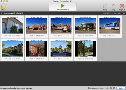
A reasonable way to tag camera images makes use of a phone and an app (Geotag Photos). The concept is simple. Cameras time stamp images, but do not have gps capabilities (using satellite or cell tower data). Phones have gps capabilities and an app can time stamp these data. A second app can match the gps data and photo by time and rewrite the exif metadata of the photo to include these location coordinates. This is the way the Geotag Photo works. You put an app on your phone and you download software to your computer. The phone app records the GPS data and the computer app uses these data to modify the exif of the image files offloading from the camera.
The phone app is displayed here with a second image representing the route taken while collecting the images.


Here is the computer software that merges the data from the phone with the individual images.
The final product might be generated using the map feature in iPhoto (the pins here represent the location of the images). Clicking a pin reveals the image.

![]()
You must be logged in to post a comment.