Finding CC images identified by Google

Google Image Search has made some changes to how an educator might go about searching for images available for use in classrooms. Google image search brings up all kinds of images, but educators should be looking for images available under a Creative Commons license. Search identifies images only some of what have any kind of identifiable license and only some of the licensed images are available with a CC license.

Here is a process educators might use. Start with image search and identify the image you want.

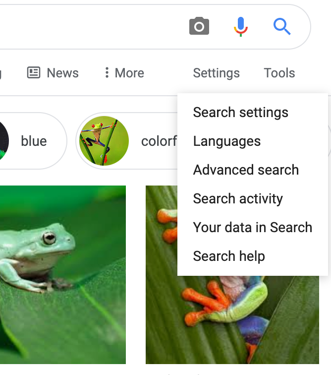
This search would reveal everything Google has located. You want to modify the search to identify those with a CC license. Under the Settings header find advanced search in the drop down menu.

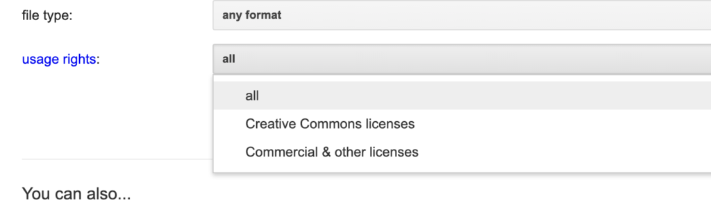
From the usage rights designation select Creative Commons.

This should now identify the images Google believes has a CC license of some type. To get additional information select the tab (red box) associated with an image you think looks useful and this will reveal more information about that image. I found a mix of sources for images and many offering ambiguous information about CC. For example, the method for clearly describing expectations might be no longer available. To be meticulous about image selection it makes sense to search the information provided for what seems a useful image and read more about the details of the CC designation (see red box within the information associated with the selected image.)

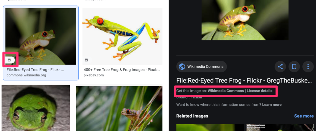
You are looking for a clear description of the CC designation.

Loading

Not ready for prime time

I am working on a new book that explores how tech tools can add value to existing resources. I call the approach “layering”. More about this project in a few months.

In exploring what might be coming, I have been considering what is available when it comes to augmented reality. This is adding information to what is visible in the world. The version of augmentation that offers information about a location is easy. How about adding information about unfamiliar objects.

The most basic form of information about an object would be identification. I knew that there are some services that attempt to identify images. I read that Wolfram had an advanced image identification service so I thought I would give it a try.

I admit that the following image is upside down and the image would be difficult to match to a database, but the image is not a shark.

notshark

I then tried what I thought was an iconic image from my wildlife collection.

notloon

Again, the Wolfram service was wrong, but suggested several different birds none of which were loons. It seems the Wolfram service attempts to learn from errors and it allowed me to describe the image. I hope I was helpful.

I did try the Google photo search with the loon image. It suggested it was a bird. Not that helpful.

Maybe I will have to offer examples of the futuristic stuff in the second edition.

Loading

ThingLink

Thinglink allows the sharing of tagged and annotated images (see link by positioning cursor over image). Thinglink works across platform and device allowing users to work from a variety of devices. In an educational setting the opportunity to work from handhelds in contrast to a camera would offer some advantages as students could annotate images as the images were collected.

If you identify yourself as a teacher when signing up for a channel, Thinglink allows you create channels (see instructions). Channels (see example) offer a way to organize images into albums. As you see from the image below images or channels can then be embedded in other outlets (this is an example of an embedded image).

Loading

Getty is a stock image provider. Typically, you pay for use of the images. Getty is now offering images to bloggers and web page authors at no cost – 35 million images are available.

It is important to understand the implications of image embeds. When you embed an image (see below), you are serving the image from the provider and not from the server you use to offer your blog or web page. The Getty approach does not offer you possession of the image.

What could be a limitation of this approach. I guess it depends on how paranoid you care to be. I heard one podcaster contend that the terms of service allow Getty to change its mind. For example, it could decide to terminate the service or possible monetize the service with ads. You can see that Getty identifies that it is the source of the image (see below). If you blog, the image would eventually disappear from your front page and might change without your awareness. I must say this would not concern me – few of those who visit my site use the search feature to locate old posts. Even if they did, what would be the harm in seeing an ad?

Loading

Geotag images with your phone

I have been working on some content explaining the educational potential of image collection and curation. A good part of the education value is likely in collecting the images (being there) and various post collection processes that use the images – organization, annotation,

Geotagging potentially represents a combination of being there and then using the location to associate other information with what is visible in the image. Potential is the key word here – there is no automatic benefit to pinning a photo on a map.

We have geotagged photos in a number of ways:

  • estimation based on memory or using another source that verifies the location
  • use of a GPS – we have a Garmin that allows us to take screen shots so we have carried tis device and our camera for some projects
  • GPS enabled camera

What prompted this new post is the discovery that Cindy’s iPhone 4S geotags images.When we were doing this before, we were using specialized cameras. It is my understanding that most phones use a type of cell tower triangulation rather than satellite referencing to figure out where they are  (Google latitude will try satellites, cell towers or known wifi spots to determine where you are ). So, the 4S will organize images within the phone according to the location of the images and transfer this location information (EXIF) as part of the file when moved to iPhoto or Flickr (note Flickr allows you to not store the location information if you consider this a privacy issue).Here is a test shot mapped in Flickr. We did this post hoc using an image we know we collected in a specific Minneapolis coffee shop. The tag was close (wrong side of the intersection). I can’t see we have conducted the same test in open spaces (plenty of those in North Dakota), but comparing GPS and phone geotag data would be interesting. Come to think of it, comparing GPS and phone location capabilities under different conditions would make a great student project.


I wondered about my Android phone. It has location capabilities. It turns out that one can take geotagged images using Camera 360.

This image was taken in my backyard and uploaded to iPhoto. Check out the location in in Google and it shows the image was taken in my backyard.

So, geotags can be added with several different smart phones.

Loading

Import EXIF Location Data (cooler than it sounds)

I have solved a problem and want to share. It is likely a problem for very few others. YET.

Here is the problem. We have a digital camera with an interesting feature. It has a built-in GPS and stores the exact location from which each picture was taken. These data are stored as part of EXIF (exchangeable image file format) in the same file as the image. If you are a Flickr user you may know that some images are accompanied by information such as the camera used to take the picture, aperture, shutter speed, etc. This is EXIF data. The longitude and latitude (I can never remember which is which) can also be stored as EXIF data.

The location data are very exact and allow images to be connected to a map (e.g., the map available within Flickr). I have been unable to get this to happen automatically (based on the EXIF data) and have had to display the data in iPhoto and then manually associate these coordinates with images once in Flickr. Some Google searches finally led to me the problem and solution.

Evidently, geo-locating images is possibly a security/privacy issue and the default setting in Flickr must be to not import location data. To allow these data to be uploaded with the image, you must locate “privacy and permissions” under the “your account” settings. There is a setting for “Import EXIF location data”.

googlegpsmap

The results are impressive. Here the position of the image (the pink dot) is positioned on the “hybrid” view of the map within Flickr.

It does make sense that you would not want the location of every image you upload to Flickr to be available to the public. Here is the technique I discovered for entering the same precise information for individual images.

I keep my images in iPhoto. You can connect images to a map location within iPhoto, but it is a little difficult to find the actual coordinates. Under the “photos” menubar heading, there is a feature “Show extended photo info”. This opens an information window that contains location information.

locationinfo

You then use the “add to your map” from the appropriate image in Flickr and enter 47.938236,-97.499985. The image will be added to your flickr map.

Loading

Creative Space

CreativeSpace is an interesting new tool for conducting image searches. The tool relies on Google image search capabilities and can be set to “safe search” which may be a useful option for educators. The revenue model appears to rely on ads.

My screen capture reflects the results from a search attempting to locate images from a local state park. I hoped to see some of my images (no luck).

Creative Space Image Search

Loading