Location, location, location

When we write about potential projects for the classroom, we typically like to use local examples from teachers we know. It seems a good strategy to assure practicality. Sometimes we have something in mind and simply cannot find an example. When this is the case we like to experiment with the tools and techniques ourselves. We learn a lot and have a sense of the options that would be available for teachers.

So, we have been thinking about the GPS as a way to “fit information to location” (just made that phrase up but I like the way it sounds). Geocaching would be a possible example but we wanted something a little new. Cindy came up with the idea of mapping local historical sites. I was going to map houses for sale in the neighborhood. I liked her idea better.

A little Internet research revealed that a list of sites, addresses and GPS coordinates already existed. This made the activity pretty easy – I had hoped I could find a list of locations by address and we could then find the GPS coordinates to see if we could map buildings to Google street view. I guess you would not have to give out the coordinates.

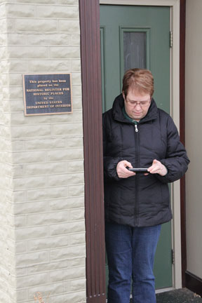
We located buildings using the maps available on our cell phones and with a Garmin Nuvi 1300 I received as a Christmas present. This Garmin can be used in a vehicle or on foot. The plan was to locate a building, switch to “where am I mode”, write down the coordinates, take a picture of the building and then put everything together once back home.

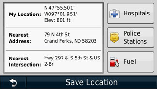
We learned something quite interested about the Nuvi by accident – it is capable of screen captures (also storing personal photos just in case anyone could possibly think of a reason for showing family photos on his or her GPS).

So, one of us would walk up to a building a record the coordinates by taking a screen shot.


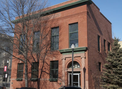
We would take a picture of the building.

We would store the coordinates using the Garmin Nuvi.


Now, you can use the coordinates above to see how well this works. Enter 47 55.501 – 097 01.951 in Google maps (see this GPA converter to understand a little more about GPS coordinates).

I had to spin the street view around –

But there was the same building I had recorded with my own camera.

BTW – the link to buildings on the list of historic places also provides access to information about the history of building. I would certainly have students read this content and also take additional photos to represent features of the buildings identified in these descriptions.

According to the documentation included with the request to declare this building a landmark:

Architecturally, this building is an outstanding example in original condition of the turn-of-the-century brick commercial style with classical detailing. Although architectural plans could not be located, the building was most likely designed by John W. Ross or Joseph Bell DeRemer, both of whom were practicing in Grand Forks at the time and actively designing commercial buildings in this style.

We did test this system in a way that involved a little more risk taking. We drove 40 miles into the country using GPS coordinates searching for a round barn (#17 on the list of Grand Forks County sites). But, that is another story.

Other images from our project are available from Picasa.

Loading

We all are part of history

primarydoc

Questions:

Approximately when was this picture taken?

What are the men doing?

Where is the activity taking place?

Several years ago Cindy was awarded a Teaching American History grant.  I sometimes get to tag along on her projects. One of the things I remember as an emphasis was providing students the opportunity to practice the historian’s craft. This is a careful process of examining and speculating about primary source documents. Trying to understand what was happening and why. There is considerable more to the process and in some ways some of concepts mirror skills that are applied when psychologists talk about observation. For example, differentiating description from interpretation. Anyway, one of the ways these concepts were presented to students was through the use of images. The link I provide describes educators in a work shop the grant sponsored going through this process with representatives from the Library of Congress via a video connection.

I have been scanning some slides and putting them on Flickr for viewing and sharing with my relatives. As I looked at some of these slides it occurred to me that they are perfect examples of the types of primary source material that offers a great opportunity to practice the historian’s craft. I am giving you a chance to see how well you can do. I have now added about enough words to this post to separate the image I have provided from my explanation of the scene it captures. If you are interested in this image, I decided to share the full size version as Creative Commons in case anyone wants to use it as a primary source document.

I am estimating this picture was taken in 1952-53. I know what was going on, but I probably did not witness this event. Some of my comments are speculative.

The men are playing a game called “dart ball”. You can see the target in the background. The teams are sitting facing each other. One of the men facing the camera is next up and he has darts in his hand. In the full size image, you can see the line on the floor behind which each player stood as they threw (underhand) darts at the target. Areas of the target represented outs, strikes,balls, and hits of different type. The target for a single is larger than the area for a triple. The area for hits is surrounded by areas of outs, strikes, etc. Each player threw until reaching base or being declared out. If I remember correctly, different teams would use different strategies. My dad’s team (the group of men you can see entirely) used to throw alternatively for singles and triples (I am thinking because it was easier to throw at targets ont the same level). I also think you could not throw at a base that was already occupied (not sure about this). Maybe alternating triple and single would be the most efficient way to force in runs. Beats me.

The scene is a rural Lutheran church basement. Teams from different Lutheran churches would car pool over to another church for an evening match and supper (they did not call it dinner). I even remember there being tournaments with trophies and the whole bit. Note the blackboard used for score keeping.

I never saw a woman throw a dart. I don’t think the Lutherans played other demoninations (again this may not be accurate).

My dad is the last man sitting on the left side (hard to see for certain). I remember him as being very good at this game, but he seems to be batting 9th. 🙂

Wikipedia has an article on dartball and it appears that it is still an active “sport”. Now, I am impressed. Would an encyclopedia have an entry on the game of dartball?

Loading