Location, Location, Location
The pictures we take are a way of representing a place we have been and the time when we were there. Sometimes we forget the connection between the stored image, the time and the place. Cindy and I have taken many trips together and have taken many pictures during those trips. We have pictures from trips taken 20, 30, and 40 or more years ago. These pictures, taken before the data of digital cameras and computers, fill boxes and books. Sometimes we come across a pile of these images and take a look. Of course, we recognize most of the people. Companies that developed prints and slides typically print a date on the images so we can kind of place the picture in time. What we often cannot place is the place - just where was that picture taken. I have taken to describing this inability to identify the location of pictures by reference to a large collection images we have collected that fall into a category. Perhaps you can relate to this cynical observation. "After a while, one mountain looks a lot like another."
Systems for organizing our collections of images offer ways to associate information with images. Some call this meta-data. We might describe the location of a picture using text. My office is located in a building positioned near the intersection of Harvard and University in the city of Grand Forks, North Dakota. This information may have little meaning to you, but you could use it if were to make the trip to Grand Forks and then to ask for specific directions that might eventually lead you to were I work. I could attach this information in the "Description" box associated with a picture of my office building I have stored in Flickr.
Flickr offers another familiar way to identify a location. It allows you to identify the location on a map.
Sticking a pin in a map
Images can be associated with a position on a map. As is the case for many Flickr features, there are several different techniques for accomplishing a similar function. We will start with the easiest.
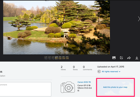
The individual page for each image offers an opportunity to add that image to a map. Select the "add this photo to your map" link and Flickr will open your map page.
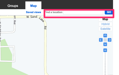
When you open this page, the view will be focused on your present location. You can search for the location where you took the picture and then add the picture. To increase precision and reduce the frustration of searching for a precise location, you can often locate a location outside of the Flickr app. For example, some of the images we use here were taken in the Chicago Botanic Gardens. Flickr will not take you to "Chicago Botanic Gardens", but will take you to 1000 Lake Cook Rd, Glencoe, IL 60022. So search for a location and then use this location in Flickr.
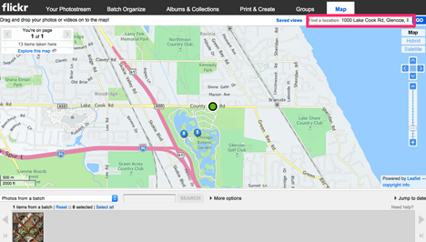
Positioning a Set of Images
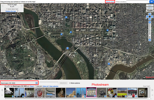
Here is a different technique used to locate a set of images taken at a common location. In this example, our example involves a set of images taken while visiting Washington, DC.. Once a set has been created, the map view can be opened by selected the "Your Map" option under the "Organize" heading. Again, you will need to search for the designed location and size according to your needs. This map looks a little different because I am using the "satellite" option. The photostream of images making up the set appear below the map. You then drag individual images from the photostream to desired locations and the images are represented by blue dots on the map (and mapped images by blue dots on the images). One final feature - you can save specific map views. Note the red box near the top of the screenshot. The link says "saved views". The idea is to create different "views" that are useful in positioning collections of images you would like to present in this fashion.
Something on the horizon
There are some very interesting possibilities that are now available, but will become more common in the future. We recently purchased a "point and shoot" digital camera from Nikon called the CoolPix P6000. We bought this camera for one reason. It has built-in GPS and stores GPS data as part of the EXIF data stored with each image. EXIF (Exchangeable image file format) sounds pretty geeky, but it simply represents information (meta-data) stored along with each picture. You might locate such information when exploring images on Flickr and such data would typically include the type of camera that took the image, whether the flash fired, the exposure duration, the date, etc. You may have found such information by selecting the "More Properties" link associated with a stored image.
By the way, you do not need to need to purchase and expensive camera to give you this capability. It is very likely that your cell phone will store GPS data if you set the proper controls (Note - some object to this capability as the default as it offers precise location data that may represent a security risk.)
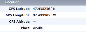
If you have the right kind of camera and you set permissions in Flickr, precise latitude and longitude are uploaded as part of the image file. Just how precise?
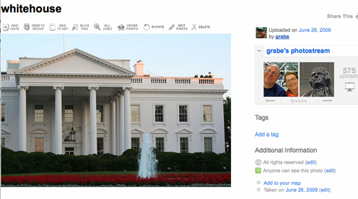
So, we assume you recognize this famous "white house". We took this picture with the camera I just described. Study the following image closely, it is the "satellite" view where flickr automatically positioned the image.
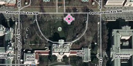
You might say - that GPS thing is not very accuate. It is quite a distance from the White House. Think carefully. The camera does not record the position of the object being photographed, it records the position of the camera. I am standing on the other side of the fence taking a picture through the fountain. You can see both the fountain and the White House in the satellite view.
Imagine what can be done when images taken with cell phones and inexpensive cameras can be positioned this accurately. We will discuss some ideas in our presentation of "tactics".