
Flickr - Image tags and geotags
Tags are available of many online social services (blog and Twitter posts, social bookmarks, images). A tag is a word or phrase that is typically the creation of a user and the idea is to use it consistently to indicate that an item is an instance of a category of items that have something in common. In contrast to image labels which are most valuable when unique, the intention is to use a tag many times to identify a common characteristic across images. A tag is an example of metadata - data about data. Data about images used in an educational setting might include date, photographer, instructor, class, project name, and . If you want, you can assign multiple tags.
Tags are mostly useful for finding content in your account or in the public offerings of others. You can search a site to locate images with a given tag. A search box appears near the top of most Flickr pages. If you enter a search term (a tag or another term), a general search will be completed. You can then narrow this search in a number of ways (see the following image - red box). You can search public images. If you have logged in, you have many more options - a public search, your own photostream, the images shared by your friends, images with a creative commons release. In addition, you can combine the selection of a collection with either a full text or a tag search.

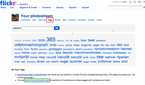
From the Flickr photo stream view (see the red box in the following image), you can access tags in a different way. This link presents a tag cloud - the most popular tags used on a site and the larger the size of the tag in the cloud, the more frequently the tag has been used. Clicking a tag within the cloud will bring up “thumbnails” of the images associated with that tag. You can also search (Jump to) images associated with a tag. This technique can be used to search for images associated with low frequency tags and images in public collection of other users. You can also search for images with several tags (see the green box in the following image).
I think most people use tags in a different way. A common strategy is to use tags to discover additional examples of a specific example a user finds interesting or useful. We are describing images here, but this strategy applies to other forms of online content to which tags are attached as well. The tactic works like this. You first encounter a single image that you find useful. If a tag has been associated with this image, you then click this tag to reveal other images that have been categorized in the same way.
Geotags
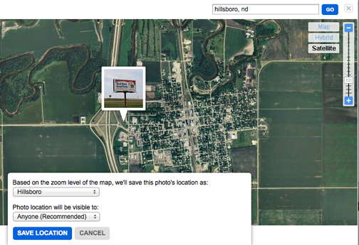
Images are captured at a location. You may be on school grounds or far from home. This location can represent a significant item of information about the image (metadata). Flickr allows you to designate the location where you took the picture. From the individual image view, you should be able to find an area of the screen that says “add this photo to your map”. If you click within this area, a map comes up. You can then either scroll around within this map or enter a location (a city name) to make it easier to begin the process of marking the location. By zooming in with the “satellite” view from this map, you can position a picture of your car in your driveway.
When you take an image with a digital camera, a lot of information is stored with the image. This is called the Exif (Exchangeable file format) data. The file identifies the date the photo was taken, the camera used to take the picture, and the aperture, exposure, and ISO settings that were used. Serious camera buffs search Flickr to locate others who shoot with a camera they like and to study the settings used when capturing particularly impressive images.
A few cameras and several popular smartphones capture location data and store it as part of the EXIF. In other words, the latitude, longitude, and altitude are stored. Cameras typically must be capable of using GPS satellites to determine these data and adding this capability raises the price of the camera.
Phones can sometimes take advantage of GPS satellites, but also cell tower or even wifi site triangulation. You may have never heard of this capability, but it will likely soon be widely available on most phones. Location based services on phones (where can I find the nearest gas station, give me directions) are growing in popularity and these same capabilities can be tapped by the camera in the phone. We presently own an iPhone 4s and a Samsung Galaxy Nexus and both phones can approximate location data and save it with the photos we take. Your phone may already do this too.
What this capability allows, in simple terms, is that images taken with these devices, when loaded to a service (e.g, Flickr) or software (e.g., iPhoto) capable of using Exif data, will automatically assign the images to a location on a map. As long as the location capabilities are turned on (typically location sensing places a heavy drain on batteries so there is a reason to turn this capability on and off), the estimated position of the camera is stored with the image.
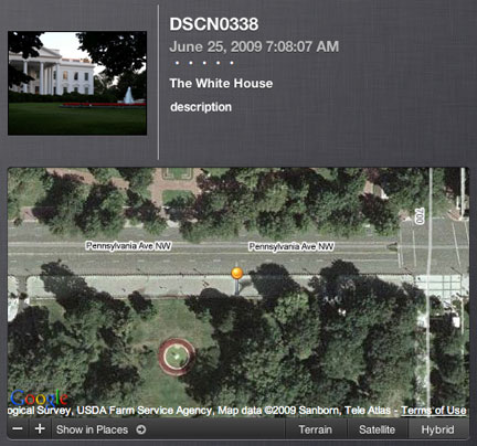
Here is our favorite demonstrate of what a GPS-enabled camera can accomplish. A couple of years ago we purchased a Nikon CoolPix P6000 camera primarily because it had built in GPS. While in Washington, DC, we took this picture of the White House.

This image was off loaded from the camera to iPhoto. This software comes with the Macintosh computer and is a tool for performing many of the functions we identify here. One capability (Places) allows the images to positioned on a world map. You can position the images manually, but iPhoto will also take advantage of GPS data stored in the Exif of an image file. When we viewed the White House photo, we checked the location of the image above and zoomed in as far as possible using the “satellite” view. Here is the position of the camera on the map (see the image that follows). If you have taken pictures of the White House, you realize that the closest you can get is the fence. What you see in the “satellite” view is a “pin” marking the location of the camera. You cannot see the White House in this view, but you can see fountain surrounded by flowers. Imagine a line of sight from the pin over the corner of the fountain and you get a sense of view we might have had from this location. Our personal experiments with cell phone cameras has not generated the same degree of accuracy, but when we know the location (e.g., a photo taken in a coffee shop) the geotag is typically within half a block.
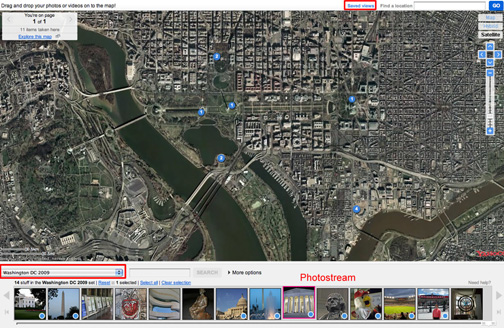
We have been focusing on Flickr and we have already mentioned the manual capability to connect images with locations. The screen capture that follows shows the map locations of a set of images collected on the trip to Washington, D.C., that was just described. Each pin in the map corresponds to a picture from the set. The locations in this case were based on the Exif geotag data rather than by manually positioning the images.
We do not want to leave you with the impression that you must make use of devices that automatically record GPS data. These cameras are certainly more expensive than a comparable camera without GPS capabilities. An argument could also be made that a learner might benefit from taking notes while collecting images and then using these notes to find where the images should be positioned on a map. However, the use of a camera or a phone as a GPS device (technically not always using satellites for location) and using this capability to record data on location also has potential. Again, we argue that technology is a way to explore your world (contrary to the common perspective that technology separates you from your world). Here, considering location as part of this experience, perhaps as might be used by geographers, is what technology adds.
