Collective Intelligence

I enjoy photographing wildlife and I sometimes make use of trail cams as part of this hobby. Trail cams are probably most commonly used by hunters to determine if the wildlife they seek are in a particular area. I don’t hunt, but trail cams offer a different way to see what animals inhabit the land we own.

Some years ago Cindy found a birdcam at a sale. This variant of a trail cam is intended for taking motion activated photos at close distances. The version she bought came with a mount allowing the camera to be precisely positioned to collect images of birds coming to a feeder. The camera was probably expensive when first sold – it has a provision for video or photos and settings for the distance to the target to allow better quality images. It is probably 8-10 years old now so the megapixels of data it collects is not close to what we now expect.

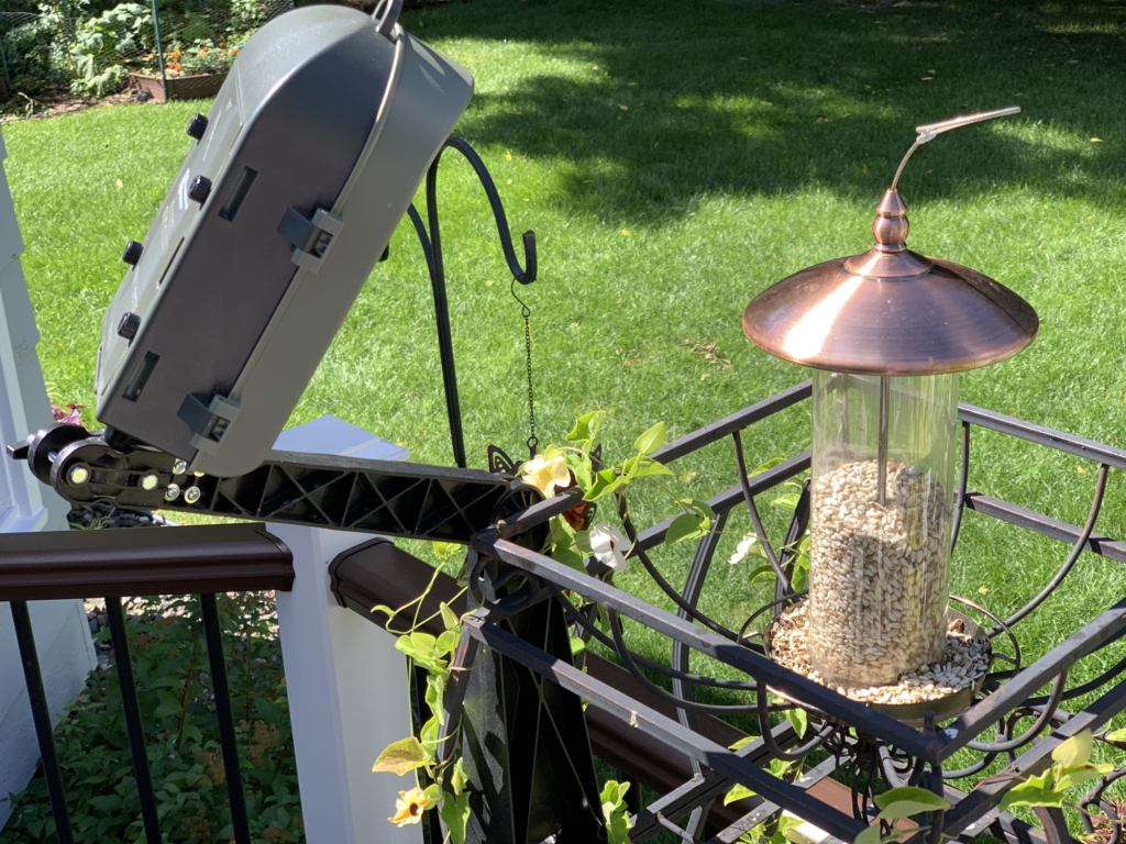
I recently joined a Facebook group – Grow with KARE – hosted by a local television station. The group is gardening/yard oriented and I had just found an interesting photo on my birdcam I shared with the group.

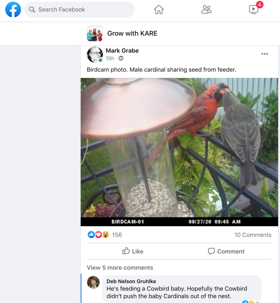
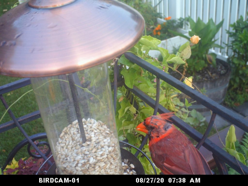
The image shows a male cardinal feeding seed to what I thought was a juvenile. Cardinals are frequent visitors to the feeder, but this feeding behavior seemed unusual. I had not witnessed it outside of a nest before. I just thought it was unusual and interesting. The photo generated a great deal of interest (at least in my experience posting to Facebook). Female cardinals are far less colorful and I had assumed that this was possibly an immature female being raised and acquainted with the feeder by the male.

Several of those responding to my post informed me that this looked like an immature cowbird. The species lays eggs in the nests of other birds and the other birds then raise the babies when they hatch. I checked out cowbird and this seems to be the case. This is likely an immature female.

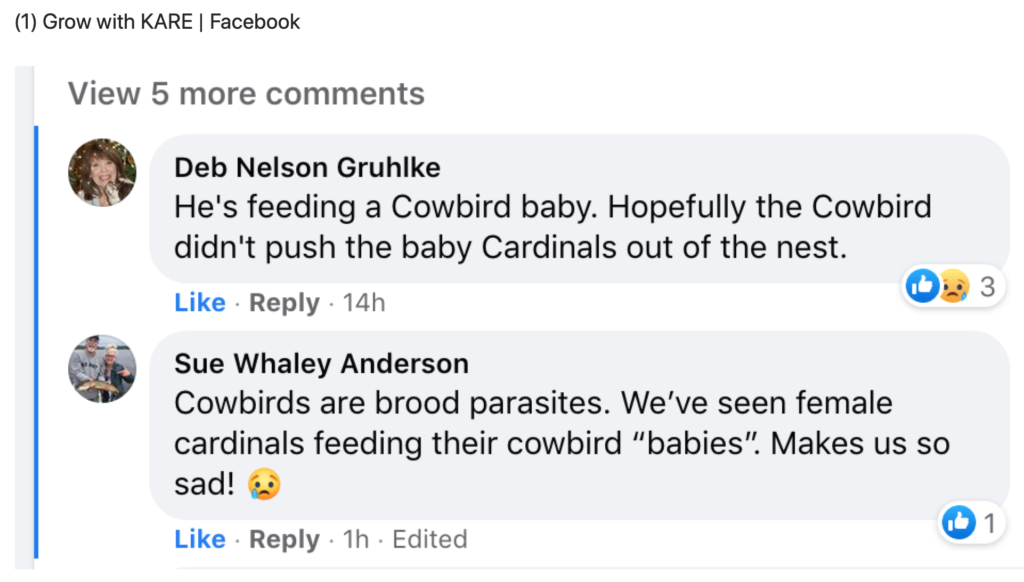
I explore photography as an educational opportunity and I have definitely learned something from the group process I experienced.

Just for the record, here are photos taken by the birdcam of male and female cardinals.
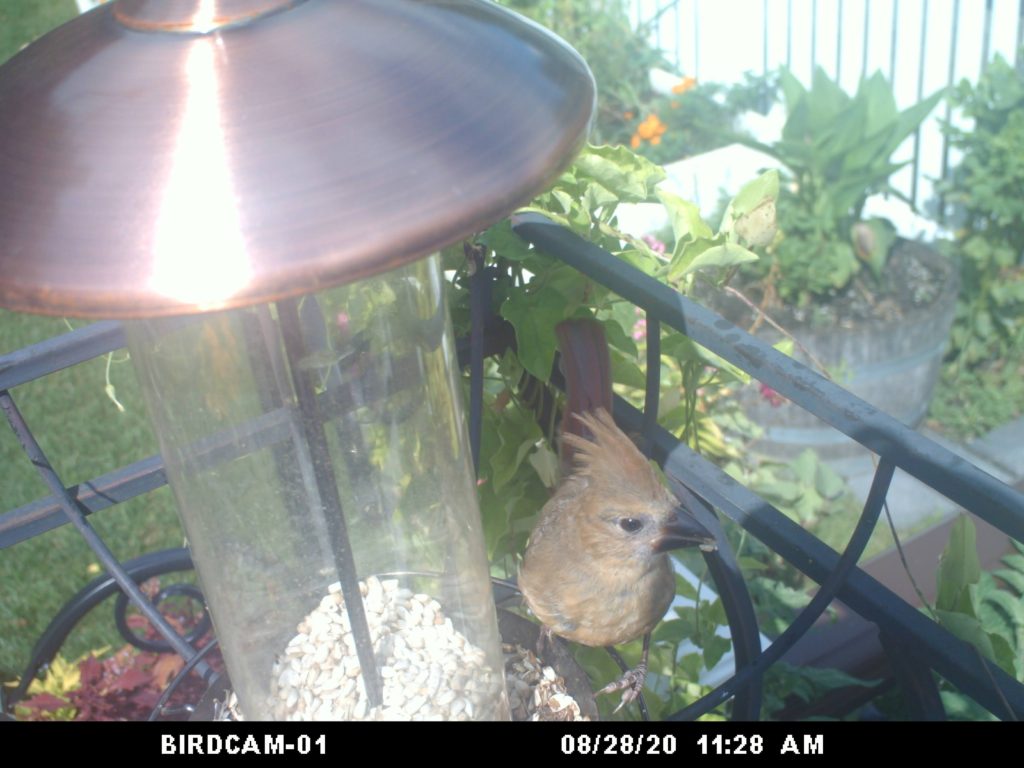
Loading

Photo collection

We recently returned from a trip to southern Africa during which we had the opportunity to view and photograph the amazing wildlife of this area. I took hundreds and hundreds of photos and kept probably half. One task I took on as a project was to select from these images some I thought students might find useful. Yes, you could create a similar collection by going to the zoo and such a visit by students would be superior to looking at my pictures. However, what I have done is create a collection I am making available under creative common licenses. If you have a use for these photos, download them. I also linked the images to online content offering additional information.

For me, bird identification is not easy. I am not a birder and I easily forgot the identifications provided by our guides. I used several online tools to try to attach accurate labels to the photos I have. There are several African birding guides available online. I found one of the best tools was Google lens. This service required I download images I had taken with my camera to my phone, but once this was accomplished Google provided a best guess, images to compare, and links to additional information.

The photos are available through Flickr and you can take a look if interested.

Loading

Geotag your camera photos

Technology in education is often associated with several stereotypes. One of specific interest to me is the assumption that technology ties a learner to a computer in a classroom in a way that reduces social interaction and physical exploration of the world. I believe I can make the case for exactly the opposite position. K-12 learners actually have few opportunities under existing circumstances to explore their world and technology can bring learners into connection with people and settings outside of the classroom. I am particularly interested in recording data and this translates into opportunities involving audio, images, and the forms of information that can be captured with probes. Think of this as capturing experiences that may always have been there, but that were not previously processed very effectively.

Part of my model for processing experiences involves the significance of context (I understand this is getting a little abstract). One aspect of context in our daily lives is location. Objects and experiences exist in physical space and where things are located can have important implications. Do you know that supermarkets are less likely to be located in areas of economic poverty? Who cares? You might if you had to walk some distance to get fresh vegetables which are seldom available from convenience stores. The broad application of GIS/GPS across disciplines allows investigations of the role of location.

In this post I am particularly interested in associating images with locations. Perhaps these images result from photographs taken of full service supermarkets in your community. I have written previously about the unique capacity of phones to capture GPS info, described how to upload images to Flickr in a way that would assure the GPS data were included, and offered examples (images in Google Earth). I feel like I am reversing course here – instead of explaining that you can do interesting things with a phone in place of a camera, I want to explain how you can now geotag camera images.

Unless you have purchased a special camera, your images are not geotagged. This is the case even with expensive cameras. Ironic isn’t it, my Canon 7D does not know where a photo I take comes from, but my phone does. Anyway, most of us have cameras and use them. Whatever the convenience of a cell phone as a camera, dedicated equipment has special advantages. I am never going to get the closeup of an eagle in flight with my phone.

A reasonable way to tag camera images makes use of a phone and an app (Geotag Photos). The concept is simple. Cameras time stamp images, but do not have gps capabilities (using satellite or cell tower data). Phones have gps capabilities and an app can time stamp these data. A second app can match the gps data and photo by time and rewrite the exif metadata of the photo to include these location coordinates. This is the way the Geotag Photo works. You put an app on your phone and you download software to your computer. The phone app records the GPS data and the computer app uses these data to modify the exif of the image files offloading from the camera.

The phone app is displayed here with a second image representing the route taken while collecting the images.

geotagpro1


geoptagpro2

Here is the computer software that merges the data from the phone with the individual images.

geotagprodesktop


The final product might be generated using the map feature in iPhoto (the pins here represent the location of the images). Clicking a pin reveals the image.

iphotogeotagpro

Loading

Location, location, location

When we write about potential projects for the classroom, we typically like to use local examples from teachers we know. It seems a good strategy to assure practicality. Sometimes we have something in mind and simply cannot find an example. When this is the case we like to experiment with the tools and techniques ourselves. We learn a lot and have a sense of the options that would be available for teachers.

So, we have been thinking about the GPS as a way to “fit information to location” (just made that phrase up but I like the way it sounds). Geocaching would be a possible example but we wanted something a little new. Cindy came up with the idea of mapping local historical sites. I was going to map houses for sale in the neighborhood. I liked her idea better.

A little Internet research revealed that a list of sites, addresses and GPS coordinates already existed. This made the activity pretty easy – I had hoped I could find a list of locations by address and we could then find the GPS coordinates to see if we could map buildings to Google street view. I guess you would not have to give out the coordinates.

We located buildings using the maps available on our cell phones and with a Garmin Nuvi 1300 I received as a Christmas present. This Garmin can be used in a vehicle or on foot. The plan was to locate a building, switch to “where am I mode”, write down the coordinates, take a picture of the building and then put everything together once back home.

We learned something quite interested about the Nuvi by accident – it is capable of screen captures (also storing personal photos just in case anyone could possibly think of a reason for showing family photos on his or her GPS).

So, one of us would walk up to a building a record the coordinates by taking a screen shot.


We would take a picture of the building.

We would store the coordinates using the Garmin Nuvi.


Now, you can use the coordinates above to see how well this works. Enter 47 55.501 – 097 01.951 in Google maps (see this GPA converter to understand a little more about GPS coordinates).

I had to spin the street view around –

But there was the same building I had recorded with my own camera.

BTW – the link to buildings on the list of historic places also provides access to information about the history of building. I would certainly have students read this content and also take additional photos to represent features of the buildings identified in these descriptions.

According to the documentation included with the request to declare this building a landmark:

Architecturally, this building is an outstanding example in original condition of the turn-of-the-century brick commercial style with classical detailing. Although architectural plans could not be located, the building was most likely designed by John W. Ross or Joseph Bell DeRemer, both of whom were practicing in Grand Forks at the time and actively designing commercial buildings in this style.

We did test this system in a way that involved a little more risk taking. We drove 40 miles into the country using GPS coordinates searching for a round barn (#17 on the list of Grand Forks County sites). But, that is another story.

Other images from our project are available from Picasa.

Loading

Night Photography

I enjoy taking photographs late at night. Must be a personality flaw.

Many folks find night photography to be very difficult. Don’t use flash. The key, of course, is to use longer exposures and a wide aperture setting. A tripod (actually a monopod for this photograph) is also pretty much mandatory.

See my post on “fireworks photography” for information on a similar topic.

Loading

A Kid and her Dora Cam

I was taking pictures as my grand kids opened their Christmas presents. Our two and one-half year old granddaughter received a Dora camera. My son gave a quick tutorial on taking pics and off she went. Maybe she just liked the flash. She aimed her camera at me and I reciprocated. My son must have off-loaded her pictures, because the following image arrived today.

The following was my perspective.

There is always a debate regarding when children should be exposed to technology and how much time they should spend. Wouldn’t it be cool to just let young kids take pictures of their world. I wonder what they find interesting? They may wonder the same thing about us.

Loading

Geotagged Pictures – Amazing

I bought Cindy a new camera for her birthday, mother’s day, or some recent holiday. We have several very nice SLRs, but the camera I purchased had the unique capability of geotagging pictures as they were taken. In other words, the camera has a built-in GPS and coordinates are stored as part of the image file.

Cindy is preparing for some interesting adventures (e.g., a trip to Russia in September) and we anticipated that the geotagging capability would have some very interesting educational applications. We returned a week or so ago from the NECC convention in Washinton, DC and the trip gave us the opportunity to evaluate what we might be able to do with this camera.

I had intended to do this demo in Picasa, but it turns out the geotag feature does not presently function in the version available for the Mac. So, I return to my Mac fanboy roots and resorted to iPhoto. I try to be even handed but what works is what works.

So, here is what one can do with a collection of tagged images in iPhoto.

dcmap

Here is the map of the collection. You can click on a pin to see photos taken at each location.

americanindianmuseum

Here is a photo taken outside the American Indian museum. You see both a small insert of the image and then the location as available from Google Maps.

whitehouseactual

Here is a photo of the White House.

whitehousegps

Here is the the photo and the location identified by the geotag. At first the map information confused me – no white house. Then it I realized, we are standing on Pennsylvania Ave. on the other side of the fence shooting through the trees to frame the picture.

All images that appear here have been greatly reduced in size to fit within the form factor required for this blog.

Loading